


MAKING PEACE WITH NATURE IN AN INNOVATIVE WAY: AFFORESTATION WITH DRONE..
The increasing population around the world, global warming, increase in environmental pollution and the need to increase the amount of product taken from unit area in agricultural production and the inability to prevent economic losses in agriculture require technological investments in agriculture.

Unmanned aerial vehicles, one of the new-generation technologies, have played a successful role in military and surveillance applications. Unmanned aerial vehicles have been used for many purposes and in various sectors such as emergency, military origin, healthcare services, traffic management, logistics, and distribution (Cai G et al, 2010). Today, it has started to be used in agriculture as a different application area. These methods were later adapted to sensitive and smart agriculture studies with the support of technology.
With the development of agricultural use of unmanned aerial vehicles, it plays a major role in improving agricultural productivity at low cost. Because the control functions of unmanned aerial vehicles have been made more useful by integrating simpler and simpler systems instead of developing multiple expensive hardware systems. Unmanned aerial vehicles play a major role in improving agricultural productivity at low cost. Because control functions are included in its system instead of developing an expensive hardware system.
The deficiencies and widespread use of drone-based systems currently present some obstacles. Chief among these obstacles is the operational difficulties brought by agricultural innovation. In precision agriculture reviews, it is emphasized that despite all the opportunities and potential of unmanned aerial systems, high operating costs and the lack of companies that offer cost-effective solutions prevent the use of UAVs in precision agriculture. However, the lack of unit cost analysis in UAV-based agricultural practices is another problem.
In agricultural insemination, UAVs are a cheaper and more convenient alternative to airplanes, offer users simpler working mechanisms, have a better sensor and camera option, and most importantly, fly in the agricultural context will contribute to the development of sustainability in agricultural production areas by being repeated easily. is considered. The presence of import-based technological products in cost inputs and outputs in agricultural studies is another challenge in this area.
However, research on UAVs has highlighted the operational challenges of implementing this technology. In seeding this area, Zhang and Kovacs (2012) found that UAVs are a cheaper and more suitable alternative to airplanes because they offer simpler operating mechanisms, have a better choice of sensors and cameras, and most importantly, in the agricultural context, flight is often repeated. They state that they contribute to the development of sustainability in agricultural production areas. (Zhang, C. H., 2012).
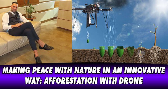
With unmanned aerial vehicles and special cameras attached to them, important data sets can be created on topics such as topography, soil, water and its management, production decision-making, and general details of plant diseases and pests. Although images often play a supporting role in these decisions, they can create very important and fast applications in growing crops. Although satellite imagery has improved in recent years and dozens of satellites have been placed in the field, companies still cannot provide enough actionable data in one day. Remote sensing applications in agriculture generally require images with high temporal resolution. Satellite images and aircraft data are very difficult to obtain and costly. For this reason, unmanned aerial vehicles with GPS and digital cameras have become the focus of research all over the world. Dr. Yaşam AYAVEFE also specializes in the development of greening and agriculture-oriented unmanned aerial vehicles that the public and private sectors can benefit from, by undertaking pioneering research and development studies in this regard.
For example, satellite frequency is sufficient for early-season fertilizer decisions. However, in areas covered by clouds or fog in summer, this frequency will sometimes be insufficient for simple applications such as variable-rate fungicides. With UAVs and the special cameras attached to them, it is even more possible to make farm management decisions. Most systems can produce a map hours after a flight, and in some cases, systems can collect instant data. This capability not only captures data on demand but also gives it a unique feature to be imported into the application immediately. With these spectral cameras, the distinction due to the differences in the spectral signatures of the plants can be caused by various endpoints.

REFERENCES
Cai G, Chen BM, Lee TH (2010) An overview of the development of miniature unmanned rotorcraft systems. Front Electr Electron Eng China 5(1):1–14 3.
Zhang, C.H., Kovacs, J.M., 2012. The application of small unmanned aerial systems for precision agriculture: a review. Precis. Agric. 13 (6), 693e712. https://doi.org/10.1007/s11119-012-9274- 5.


-
 KARAYOLLARI DAİRESİ, GÜVERCİNLİK VE SADRAZAMKÖY’DEKİ ÇALIŞMALARI TAMAMLADI..
-
 Arıklı, 23 Nisan Ulusal Egemenlik ve Çocuk Bayramı dolayısıyla mesaj yayımladı..
-
 Tosunoğlu: Vekil olmaktan mutlu değilim
-
 Dünyada israf edilen gıdalar, yetersiz beslenen insanların 2 katından fazlasına ..
-
 Oğuz: 3 ayda bin 462 kişiyi ülkeye almadık, 827 kişiyi deport ettik
-
 YÖDAK’ın Araştırılması Komitesi Başkanı Hasan Küçük oldu
-
 Stefanu’dan Hristodulidis’e sert eleştiri: Kıbrıs sorununda izlediği çizgi esasl..